Your cart is currently empty!
Version 1.6.0
We’ve skipped a few versions that I didn’t end up fully releasing so now we have jumped to 1.6.0.
The big changes coming out with 1.6.0 are new readouts and readouts customization and a new set of tools for choosing waypoints for navigation.
There is also a change on how you can download/update coming out along with this version, but that has it’s own post that you can read here.
1.6.0 Changelog
- Added Settings menu for readout groups
- Readouts can be customized with size, position, colors
- Altitude, heading, speed update with GPS
- Smart waypoint select
- Can select waypoint from any “point” layer
- Create waypoint and start navigation if no close by waypoints
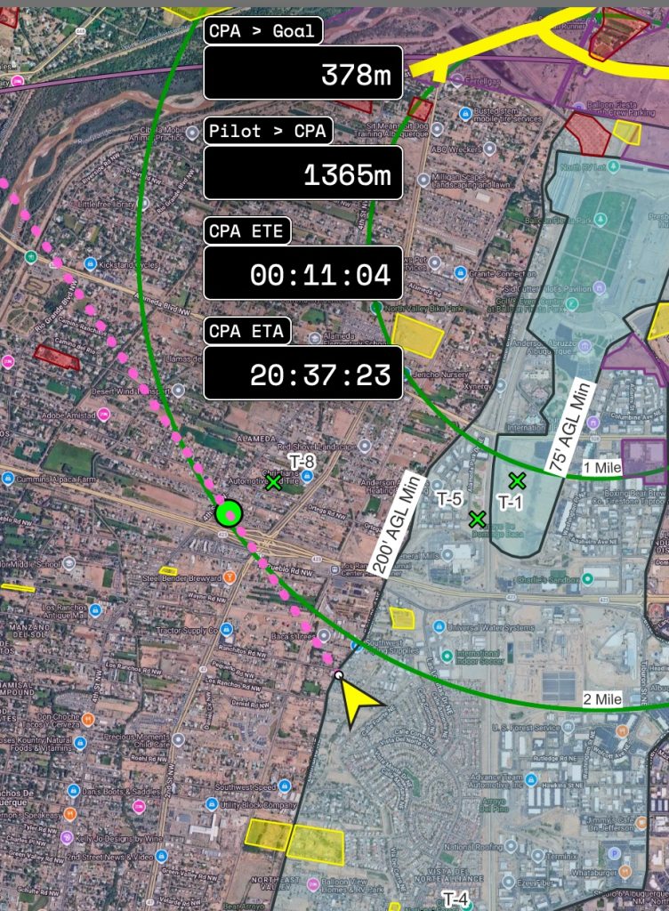
- Changed how CPA point is rendered on the map
- Create custom groups of readouts
Fix
- Initial value for magnetic variation is now a string
- Only reset LtaGoLayers
Custom Readouts
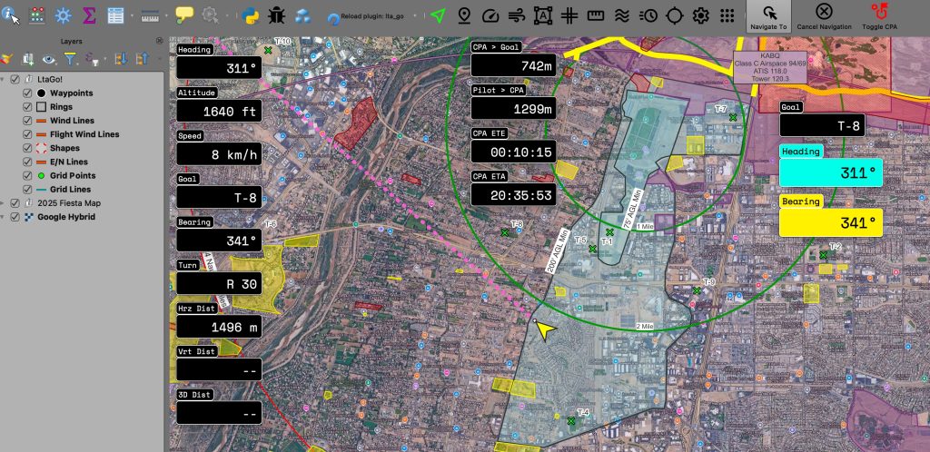
Readouts are now much more customizable. You can create separate groups, and positions, change size and colors. The individual groups can be position independently from each other. All readouts will show or hide when selecting the readouts button.
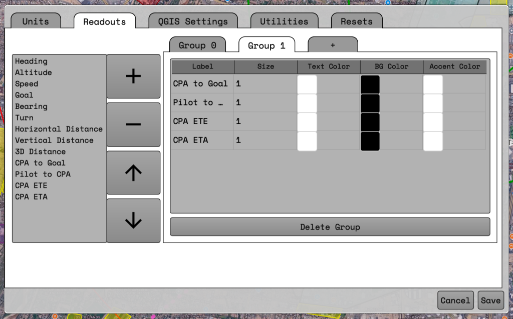
Readouts can be modified by going into the settings window. At least one group should always be present.
Creating a new group with readouts
- To create a new group click on the tab showing a ‘+’. The group will be empty by default.
- Select a readout on the list on the left of the window.
- Click the large ‘+’ button in the middle. This will add the readout into the group table on the right hand side.
- Repeat steps 2 and 3 for all desired readouts.
Deleting a group of readouts
- Change to whichever group you would like to delete by selecting the tab along the top of the right hand box.
- At the button of the box click the ‘Delete Group’ button.
- The group will be deleted.
Reordering a readout
- Select a readout on the right hand side.
- Press the up or down arrows in the middle
- Readout should move in whatever direction was clicked.
Deleting a readout
- Select a readout on the right hand side.
- Press the ‘-‘ button in the middle.
- Readout will be removed from the group.
Changing the size of a readout
- Select the number in the size column of the row you want to change.
- Sizing is relative. ‘1’ is the default sizing. ‘2’ will double the size.
- Decimals can be used. ‘1.5’ or ‘0.5’ are valid entries.
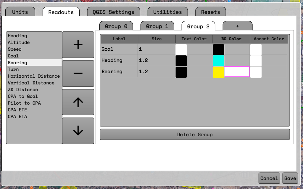
Changing the color of the readout
- The colors that can currently be changed are text color, background color, and border color.
- To change a color click on the colored square under the appropriate column.
- A color selection window should appear.
- Choose whichever color you would like.
When you are done changing the readout settings make sure to press the “Save” button on the Settings window.
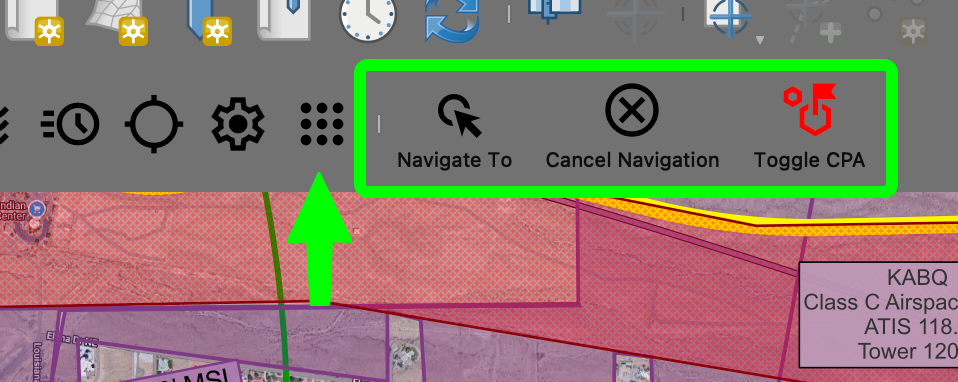
Waypoint Navigation
A new toolbar has been added for navigation. This allows for you to start navigation to a new location, cancel navigation, and toggle the Closest Point of Approach waypoint visibility.
The grid button below will show/hide the toolbar. If you want to move the toolbar you can click and drag the toolbar using the little line to the left of the ‘Navigate To’ button.
Navigate To button
The “Navigate To” functionality has had some under the hood changes and a couple functional changes to how you can use it. The first big change is it will now use all visible layers to select a point for navigation. If the selected waypoint has a “label” or “name” attribute that will be used for the goal name, otherwise the 4/4 will be used.
Under the hood selection of a waypoint should be a little easier as it will search for an available waypoint within a distance of the clicked point. This should help while flying and not having to click exactly where the point is.
If a waypoint is not found close to the clicked point a waypoint will be created and navigation started. The 4/4 will be shown for the goal name if needed for any goal declarations.
Toggle CPA button
The toggle CPA will show or hide the Closest Point of Approach to your currently selected goal. This only affects the rendering of the waypoint on the map. All other CPA calculations will still show on the readouts. Hiding the CPA should hopefully be a band-aid for any flashing of waypoint labels .
Leave a Reply